Low and High Rigg Galoppen




| Senior Member | £10.00 | |
| Senior Non-Member | £11.00 | |
| Junior / Student Member | £5.00 | |
| Junior / Student Non-Member | £6.00 |
To enter you must first Log In or Register your Details with SiEntries.
Terrain: Steep open fell with crags and rock detail, some marshy sections. Courses avoid the bracken and steeper cliffs.
Car Parking: On the old A66 near Burns/Naddle Bridge. Please park neatly along the verges.
Directions: Please approach from the A66 taking the turnoff for Burns.
Toilets: At assembly.
Starts: 10:30 – 12:30
Walk to the start from assembly is around 300m with around 50m climb.
Near and far finishes: Courses close at 14:30. It is vital that you download.
Far finish (Brown, blue and green) - 1.6km and generally downhill from the finish to assembly. Please follow tapes. Please note, taped route does not use the public footpath through Row End that we have used in the past – please avoid this.
Near finish (All other courses) – 300m from assembly, follow tapes.
Results will be displayed at download.
Pre-entry: open and is available for all courses. Prices: seniors £10 and juniors/students £5. If you are new to orienteering and would like to go round as a group or in a pair, just enter one person and let us know how many additional maps you would like.
Entry on the day: for the White, Yellow, Orange and Red courses only subject to map availability (Senior £10, Junior £5)
White and yellow maps to be collected from registration.
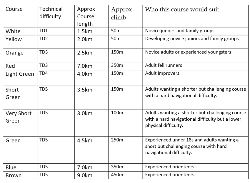
Maps: A3 1:10000 for Brown, Blue and Red. 1:7500 A3 for Green. A4 1:7500 for all other courses.
Green circles (ISOM bushes or trees) are mainly small trees.
There is no bracken screen on the map and although bracken is present, courses are designed to avoid these areas.
Rough open is shown as white on the map. The enclosures of trees are shown in light green. These areas are runnable forest. Walled fields are shown on the map as fast open in yellow/orange.
Boulder sizes vary. Descriptions give boulder heights.
Uncrossable walls/fences are shown with purple line and must only be crossed at marked crossing points point.
Control Descriptions: Loose in start lanes and on the maps
Timing: Sportident – Controls will be SIAC Enabled. You will need to punch the Start and Finish.
Dibber Hire: Free but £30 payable if lost. To pre-order, leave the SI number blank during entry process and collect from Download on the day. Also available for entry-on-the day.
SAFETY
• Clothing: Shorts are allowed, but competitors should be tick-aware and thoroughly check after the event.
• Weather: The area is exposed and if cagoules are compulsory, competitors will be advised in the final details and/or by signage in the field.
• Whistles are compulsory.
• There are grazing sheep and cows in the area. Please do not run directly at them.
• There are cliffs and crags on the area, the rock can be very slippery when wet.
• Safety bearing for all courses is NORTH.
On High Rigg, to the road, follow tapes to assembly.
On Low Rigg, to the road, follow tapes to assembly.
• White, Yellow and Orange courses do not go out onto the southern area of Low Rigg. If these competitors accidently go through a crossing point onto the fell, they will see a sad face sign telling them to go back into the field.
• Other members of the public and the farmers may be in the competition area. Please be mindful and cheery as we are grateful to them for allowing us to use their land.
• Route to the start and from the finish. Please close gates after you.
• The nearest defibrillator is located at The Lake District National Park Office at Threlkeld. CA12 4TT W3W negotiators.repair.dwelled.
• All courses use gates and wall crossing points. Please be respectful of other users who might be a bit wobbly on the steps and give them time to descend safely.
Dogs on leads - no dogs on the course or on route up to start. If you’d like to take your dog for a walk, please use the public footpaths.
COURSES CLOSE AT 2.30PM. PLEASE REPORT TO DOWNLOAD AT ASSEMBLY EVEN IF YOU DO NOT COMPLETE YOUR COURSE
Nearest A & E
Cumberland Infirmary
Newtown Road
Carlisle
CA2 7HY
NY 387561 What3Words : ///cool.pines.tribune
Mary Hewetson Cottage Hospital, Crosthwaite Road, Keswick – Minor Injuries Walk in
What 3 words : ///exclusive.tooth.flap
Postcode: CA12 5PH
Officials:
Organiser – John Ferris-Worth (WCOC)
Planner – Julie Ferris-Worth (WCOC)
Controller – Karen Parker (BL)
Please note:
From 1st January 2026, participants who are not members of British Orienteering are not covered by British Orienteering’s public liability insurance.By entering this event, you acknowledge that you are taking part at your own risk. For example, if you were to accidentally injure a member of the public or damage property during the event, you would not be covered.
View the Event Disclaimer / Terms and Conditions.
View the Event Cancellation / Refund Policy.
Save the date and share